
Walk a Cedar Falls Street
Start with a precise street number, not a person’s name. Cedar Falls keeps the strongest address-first tool in its Property Viewer, while Black Hawk County keeps assessment and recorded-title evidence. These systems describe parcels and legal interests. A deed-holder field may identify an owner, but it does not prove that the owner lives there. The same caution applies to a tax-mail recipient. A sound street directory separates what each source says from what the researcher hopes to learn.
The path moves from map evidence to title evidence, then to records that may help with occupancy. Save the PIN, the parcel identification number, and the legal description before leaving the map. Those keys survive many spelling, unit, and street-label differences.
- Find the address in the Cedar Falls Property Viewer. Save the PIN, subdivision, legal description, and deed-holder spelling.
- Open nearby parcel polygons to continue by street. Use the viewer’s 300-foot spatial tool when an area is more useful than a whole road.
- Check the official Black Hawk County mapping entry for assessor context. The live Beacon controls were not verified during research.
- Search the Recorder’s AVA index for the deed, then follow grantor and grantee names with the legal description.
- Use the limited voter-status tool for a known name and ZIP. For older occupants, turn to address sections in historical directories.
Cedar Falls Street Search Fields
The Property Viewer offers verified local fields that make a by-address review repeatable. Its main search accepts a place name, PIN, address, or subdivision. An owner query checks DeedHolder1 or DeedHolder2 with OR logic, so either holder field can match. Search suggestions and first results are capped at ten. Parcel query results can load in later pages.
| Viewer control | Input | How it helps |
|---|---|---|
| PlaceName | Text | Find a named place shown in results |
| PIN | Text | Use the parcel’s stable local key |
| Address | Text | Locate the physical street site |
| Subdivision | Text | Group parcels under a subdivision |
| DeedHolder1 or 2 | Contains, OR | Find either displayed holder |
| Parcel buffer | 300 feet | Use contains, intersects, or within |
Popup fields include unit, ZIP, contract holders, five tax-mail lines, land and building values, zoning, neighborhood, ward, precinct, schools, and coordinates. Treat them as leads. The viewer is not a survey, and a school field is a parcel attribute rather than proof that anyone attends that school.
Cedar Falls Address Terms
Four terms prevent common street directory mistakes. They explain why a search based only on the number printed on an envelope can miss a valid land record.
- Parcel
- A mapped piece of land linked to a PIN and legal description.
- Situs address
- The physical parcel address, distinct from the tax-notice destination.
- Plat
- A recorded map identifying lots, blocks, streets, and subdivision lines.
- Criss-cross directory
- A directory arranged by street and house number for use when a name is unknown.
The Cedar Falls parcel service publishes the field schema used for local address research.
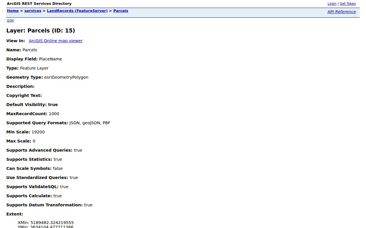
The captured schema confirms which address, holder, value, and district fields actually exist.
Cedar Falls GIS exposes both site and tax-mail information. A person can receive notices elsewhere, and the record may display several TaxMailTo lines. A legal description can remain useful when a street number or unit changes. This distinction is one of the best checks in the Cedar Falls street directory.
Cedar Falls Records by Address
No single roll answers every question along a Cedar Falls street. The map locates parcels. The assessor describes taxable property. The recorder preserves title instruments. City systems add permit or code history, while old directories may identify listed occupants.
| Address record | Keeper | What it establishes | Access |
|---|---|---|---|
| Parcel and GIS | Cedar Falls GIS | PIN, site address, holders, values and districts | Public viewer and query service |
| Assessment | County Assessor | Value, traits, classification and owner context | County entry and Beacon |
| Recorded land records | County Recorder | Title events, plats, liens and easements | AVA, office and historical books |
| Transfers | Auditor and state archive | Older land and town-lot trails | Scans from 1868; archive series from 1866/1880 |
| Permits | City of Cedar Falls | Dated work or land-use records | CF1Stop, dashboard or request |
| Address listings | Historical Society | Names published for an address and year | Appointment or staff research |
Access is not web-only. The Recorder is at 316 E 5th Street, Room 208, Waterloo, and can be reached at 319-833-3012. City records can be requested in person, in writing, by phone, or electronically under Iowa Code chapter 22, subject to exemptions and reasonable actual costs.
Deeds Along Cedar Falls Streets
Use the Black Hawk County AVA index after identifying the parcel. Search the holder as a grantee, then match the legal description. A grantor gives an interest; a grantee receives it. Record the instrument number, date, parties, return address, and any parcel reference on the image.
To move back, search the seller as an earlier grantee. Mortgages, releases, assignments, easements, plats, affidavits, and liens may appear in the same index, but they are not all transfers. Research did not establish AVA’s online cutoff, exact controls, or image fees. If the web trail stops, contact the Recorder and use Auditor transfer books by subdivision or section, township, and range. Those books were made searchable back to 1868 in a preservation project announced in 2024.
The preservation work is important for a street directory because it creates a second route when a modern search fails. The older trail is based on land descriptions, not a promise that every historic street number will appear. County land-transfer archive series begin in 1866, while the town-lot series begins in 1880. Confirm the matched lot before assigning an old name to a modern parcel.
Cedar Falls Streets and Permits
The city’s Maps hub links the Open Building Permits dashboard as well as property, flood, cemetery, street-index, and zoning tools. CF1Stop can search permit data, register trade licenses, and accept trade-permit applications. RequestTracker routes questions about inspection, permits, land use, code enforcement, illegal construction, maintenance, and public nuisance.
A permit can date an addition, demolition, sign, alteration, or land-use action. It is not a list of residents. Public inspection did not verify a full historic cutoff or stable applicant-search fields. When the portal cannot answer a narrow question, use Cedar Falls’s Open Public Records form. Give the house number, street, date range, and record type. Iowa law grants access to existing public records, but does not require the city to create a new people list.
Cedar Falls Street Voter Limits
Iowa’s public voter-status search asks for first name, last name, and ZIP. The county polling tool accepts ZIP or city and returns polling-place details. Neither offers an open, by-address list of every voter on a block. A full list request follows Iowa Code sections 48A.38 and 48A.39, with jurisdiction, period, status, format, purpose, and fee rules.
Safe at Home can shield an eligible participant’s actual address. A missing result may reflect spelling or ZIP input and is not proof that a person is absent. Commercial use of voter registration information is prohibited. Keep a narrow voter result distinct from parcel ownership, and do not publish a household claim the official tool does not make.
Older Cedar Falls Street Listings
The Cedar Falls Historical Society lists nonannual city directories from 1874 through 2014 and telephone books from 1917 through 1959. A street or reverse section can connect an address with a listed name where that format exists. Copy the volume, year, page, spelling, initials, spouse notation, and address. Publisher rules vary, so check each book’s key rather than assuming one abbreviation system covers the shelf.
Missing years matter. The holdings do not supply a volume for each year, and a blank is not evidence that a household left. Use a nearby listed year or telephone book, then ask society staff for appointment research. The full shelf belongs on the Cedar Falls city directory page; this use stays address-first. The library links the society, cemetery search, Fortepan Iowa, and Historical Cedar Falls, but does not publish a full obituary or microfilm inventory.
Bridge Cedar Falls Address Changes
The official Street Name Index is the first bridge when an old label does not match the modern map. Then compare the subdivision, lot, block, legal description, annexation layer, plat, and deed. A 1909 Sanborn map offers sixteen sheets of building and street context. County aerials add 1941, 1964, and 1979 views. Historic footprints help date change, but are not surveys.
No verified local renaming or renumbering timeline was found. Do not assign a year to a change without Planning, GIS, or record confirmation. Keep ZIP labels apart from city limits too. USPS groups 50613, 50614, 50647, and 50660 under a Cedar Falls mail label, although Janesville and New Hartford appear in county ZIP tools. Verify city jurisdiction in GIS and delivery through USPS.
Cedar Falls Street Directory Limits
A parcel field is not a census of a home. A mailing address may identify the tax-notice destination. A deed proves an interest transferred, not where either party lived. Permit and court entries record events. Vehicle-owner details face state and federal limits, and no public utility-customer lookup was found. Protected voter addresses, sealed cases, and other exceptions can leave a deliberate blank.
Use address records lawfully. Research Cedar Falls streets for family history, civic questions, property curiosity, or personal safety, never to stalk, harass, intimidate, or harm anyone.
Confirm key facts with the custodian. The street directory is strongest when claims stay modest: GIS identifies a parcel, a deed identifies a title event, and a dated directory identifies a published listing. Combining them can support a careful history, but it cannot turn inference into proof of current occupancy.