
Cedar Falls Neighbor Record Sources
The immediate block has several official layers. Cedar Falls GIS identifies parcels and public property fields. County assessor and Recorder sources add assessment and deed context. City permit systems can date work at an address. Voter information is much narrower, and the city association page supplies group names without publishing people.
| Source | What It Shows About the Block | Access |
|---|---|---|
| Cedar Falls Property Viewer | Adjacent PINs, addresses, holders, tax-mail, zoning, wards and subdivision | Public map and query |
| Black Hawk Beacon | Parcel cards, values and property traits | Official entry; live fields not captured |
| Recorder AVA | Transfers, mortgages, easements and plats | Public portal; cutoff and fees not verified |
| CF1Stop and permit dashboard | Permit or project activity by address | Public entry; field coverage incomplete |
| Voter status or list | Person status or authorized list geography | Narrow search; full list restricted |
| Neighborhood associations | Public group names and links | Official city list; no member roster |
| Historic maps and aerials | Older buildings, streets and land context | 1909 Sanborn and dated county aerials |
This block view is deliberately different from a whole-street review. Use the Cedar Falls street directory when the goal is to follow every parcel along a named road.
Mapping Cedar Falls Neighbor Parcels
The Cedar Falls Property Viewer offers a reproducible route from one address to nearby land. Search controls accept PlaceName, PIN, Address, and Subdivision. Results display place and address, with up to ten suggestions and ten initial results. The owner query checks DeedHolder1 or DeedHolder2 with contains logic.
- Search the exact target address and open its parcel.
- Save the PIN, address, subdivision, legal description, and map date.
- Click each neighboring polygon or run the 300-foot parcel buffer.
- Choose contains, intersects, or within based on the question.
- Save each nearby PIN before checking owner or tax-mail fields.
The sequence prevents a road, easement, pending lot, or parcel across a broad right-of-way from being mistaken for a next-door home. Results load in pages, and each item is titled with PIN and address. A buffer can cross streets, so map distance never proves a social relationship.
Cedar Falls Neighbor Map Fields
The parcel service publishes fields for Address, UnitNum, City, Zip, DeedHolder1 and 2, ContractHolder1 and 2, TaxMailTo1 through 5, Legal, values, Subdivision, ZoningCode, Neighborhood, Ward, Precinct, schools, and coordinates. This is useful detail, but field names must keep their plain meaning. Deed-holder and tax-mail names are not a household roster.
- PIN
- The parcel identifier used to keep the same piece of land tied across records.
- Situs address
- The physical location shown for the parcel.
- Tax-mail address
- The destination for tax notices, which may be somewhere else.
- Legal description
- The lot, block, subdivision, or land description used in deeds.
The successful manifest image comes from the official Cedar Falls parcel layer.
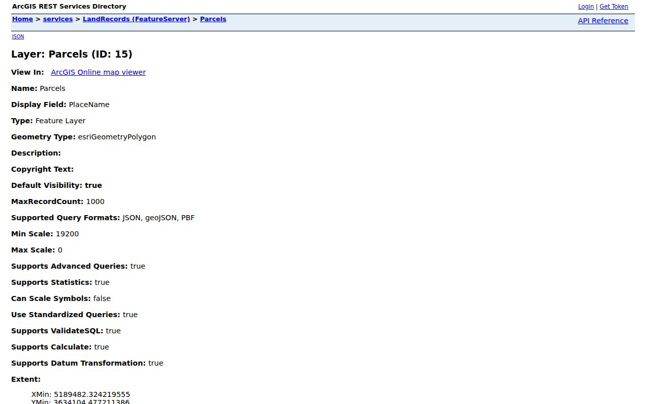
The field schema supports a precise neighbor search without reproducing live resident names. GIS is still a discovery tool, not a legal survey or a certified deed.
Cedar Falls Neighbors by Layer
Nearby parcels make more sense when the correct map layers are visible. The viewer includes lots, pending lots, easements, setbacks, rights-of-way, subdivisions, minor plats, sections, annexations, zoning, wards, and precincts. The city Maps page also links the current flood map, street index, cemetery search, and building-permit dashboard.
Turn on only the layer needed for the question. Zoning describes a land-use district, not the people at an address. Ward and precinct fields give civic geography, not a voter roster. School fields are parcel attributes and do not prove where a child attends. An annexation shape can explain jurisdiction, but no verified Cedar Falls address-renumbering timeline was found, so a specific number change should be checked with Planning or GIS.
Compare the GIS legal description with AVA before joining two records. A matching subdivision and lot is stronger than a shared street name. County maps are compiled from plats, surveys, deeds, and contracts and carry an independent-verification warning.
Cedar Falls Neighbor Property Activity
The Black Hawk County Recorder's AVA land-record index can connect a parcel to transfers, mortgages, easements, plats, and other recorded instruments. Start with the GIS PIN and legal description, then compare the holder spelling. A deed transfers an interest. It does not prove who occupied a Cedar Falls home on the recording date.
For city activity, CF1Stop and the Open Building Permits dashboard can add an address-based permit or project. RequestTracker has categories for building inspection, permits, zoning or land use, code enforcement, property maintenance, public nuisance, and open public records. No stable full historical table or applicant-name fields were captured, so ask for a dated and address-specific existing record instead of expecting a blockwide export.
Permit records may explain construction, alteration, demolition, a sign, or a land-use action. They do not form a directory of nearby people. If a portal stops short, request the named permit category and date range from Cedar Falls.
Cedar Falls Neighbors and Voter Limits
The public Iowa voter-status form requires a known first name, last name, and ZIP. It cannot take one Cedar Falls address and return all registered people nearby. The Black Hawk polling-place helper accepts ZIP or city and supplies precinct or polling context, not a named roster.
A fuller voter-list request may select jurisdiction, election period, party, status, and output format, but Iowa Code sections 48A.38 and 48A.39 impose purpose rules. Commercial use is prohibited. Social Security numbers and driver or nonoperator identification numbers are excluded. Participation history shows that a voter took part, never a ballot choice.
Safe at Home can hide an actual address or supply a substitute. Protected voters must not be treated as missing or false registrations. A responsible Cedar Falls block search accepts that a real person may not appear at block level.
Cedar Falls Neighborhood Connections
The city's official neighborhood association page names five groups or district resources. It links to public group pages, but it does not provide a universal member directory. An address near a district does not prove that a resident joined its group.
| Listed Group | Safe Use |
|---|---|
| College Hill Partnership | Public district and group information |
| Community Main Street | Downtown civic context |
| North Cedar Neighborhood Association | Public neighborhood resource |
| Overman Park Neighborhood Association | Group link and survey context |
| South Main and Greenhill Association | Public association information |
The successful capture shows the official Cedar Falls association inventory.
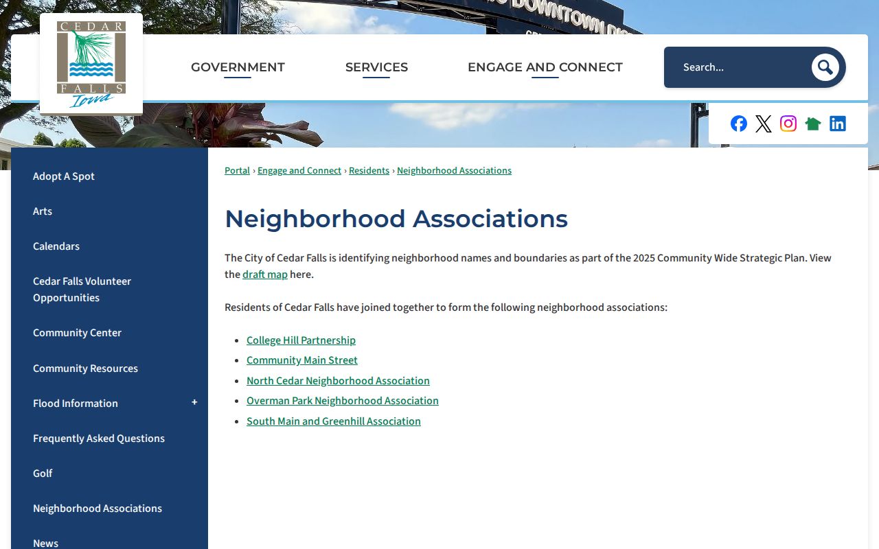
The image is a civic contact layer, not evidence of membership. No official congregation, block-watch, or civic-club resident roster was located, so none should be inferred from event notices.
Overman Park's Block Survey
Overman Park supplies a useful local history layer. The city reports that about 465 properties west of the Downtown Historic District were reviewed in a street-side survey supported by University of Northern Iowa History students and a Certified Local Government grant. The city page links final results and a report.
This is a survey of historic resources, not a roll of current Cedar Falls residents. Pair a surveyed place with its present GIS PIN and legal description. Then compare the report with the 1909 Cedar Falls Sanborn map or Black Hawk County aerials from 1941, 1964, and 1979. The dates can explain changes in buildings and street form without inventing a resident story.
The project is also a reminder that block research can stay useful without publishing names. Building age, parcel shape, zoning, permits, and a documented historic district context can answer many neighborhood questions on their own.
Cedar Falls Neighbor Tool Choices
Official rolls and commercial compiled tools answer different questions. The official record identifies its keeper, date, field meaning, and correction route. A compiled service may blend filings and purchased data without showing when a source changed. It may also merge same-name people or retain an old address.
| Choice | Strength | Limit |
|---|---|---|
| Official parcel and deed records | Named custodian and clear land fields | Ownership is not occupancy |
| Official voter route | Current status under Iowa rules | No address-to-all-voters search |
| City permits and associations | Local project and civic context | No resident or member roster |
| Commercial compiled category | May gather many old clues | Freshness, identity, and correction limits |
Use the custodian when a field needs correction. Assessor errors go to the Assessor, deed questions to the Recorder, voter status to Elections or SOS, and city permit records to Cedar Falls.
Cedar Falls Neighbor Privacy
A parcel map cannot show every person at an address. Tax-mail can belong to a notice recipient elsewhere. Utility-customer and delivery records were not found as public Cedar Falls sources. Motor-vehicle personal data is restricted. Safe at Home, sealed court records, and other confidentiality rules create intentional gaps.
Keep notes at parcel and source level. Record the map date, PIN, legal description, and the exact meaning of each field. Do not publish protected addresses or infer a household from a deed-holder, school field, association link, permit, or court event. A no-result is not proof that a person is absent.
Respect the block. Use Cedar Falls block records only for lawful personal and civic purposes. Never use public data to stalk, harass, threaten, or intimidate someone.